How Does GPS Work? Explained Simply in 5 Minutes (2026)
In brief
Curious how GPS pinpoints your location anywhere on Earth? Learn how satellites, signals, and math work together to guide you — explained simply.
Key Takeaways
- 1.GPS uses timed radio signals from at least 4 satellites to calculate your position through a process called trilateration — accurate to within 3–5 metres for most devices.
- 2.Your GPS receiver only listens; it never transmits, which is why the system works for unlimited users worldwide simultaneously at no cost.
- 3.Modern smartphones combine GPS with GLONASS, Galileo, Wi-Fi, and cell tower data (A-GPS) to deliver faster, more accurate location fixes in urban and indoor environments.
Think of it like this
Think of GPS like receiving letters from four friends who all mailed you postcards at exactly the same moment. If one postcard arrives seconds later than the others, you can calculate that friend lives farther away. By knowing the precise distance to all four friends simultaneously, you can pinpoint exactly where you are on the map — down to the street you're standing on.
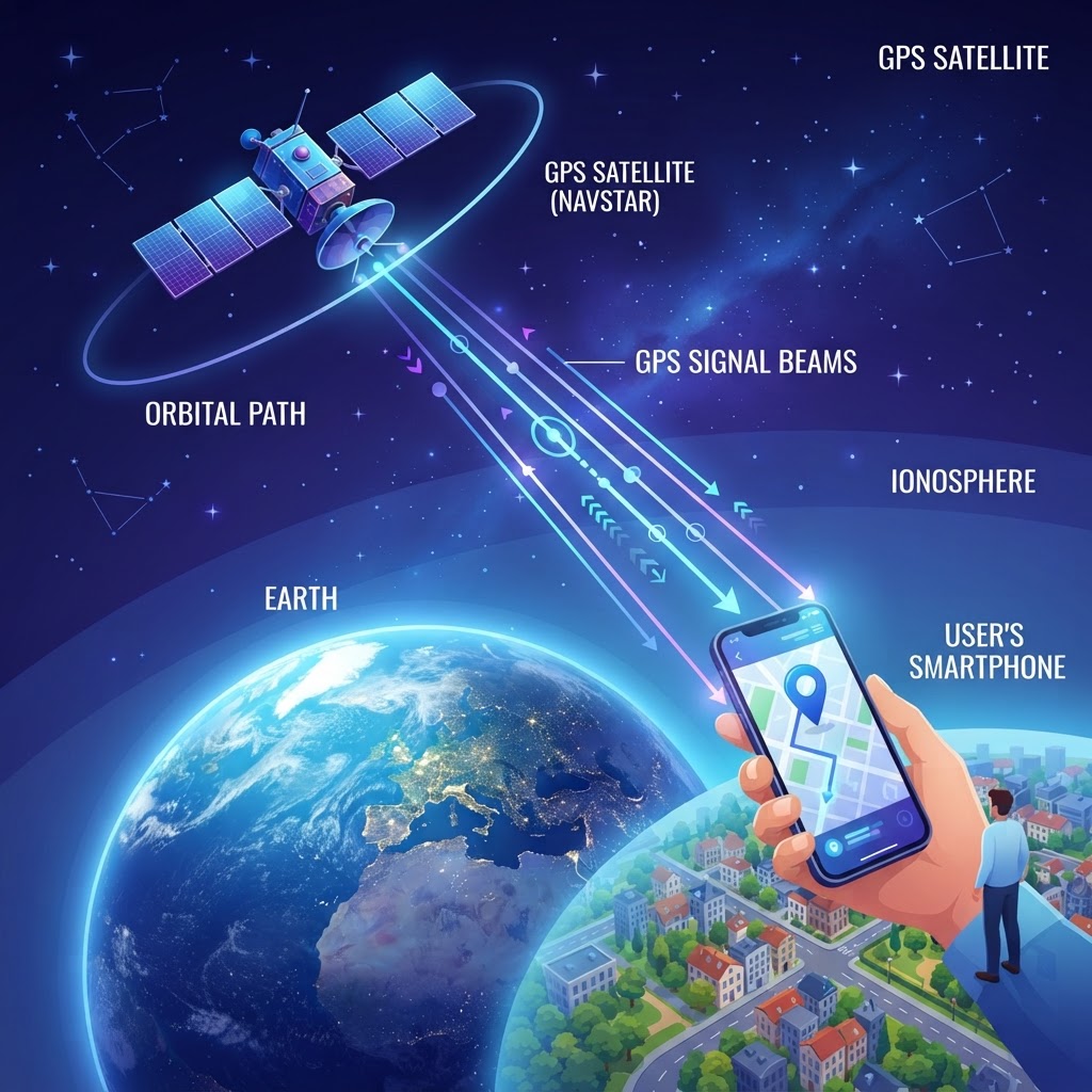
GPS — the Global Positioning System — works by measuring the time it takes for radio signals to travel from satellites orbiting Earth to a receiver in your device. By calculating the distance from at least four satellites simultaneously, your phone or GPS unit can determine your exact latitude, longitude, and altitude. For kids: Imagine you're blindfolded in a park, and three friends shout your name from different spots. By hearing how loud each voice is and which direction it comes from, you can figure out exactly where you are — that's basically what GPS does, but with satellites in space!
1. What It Is
GPS is a satellite-based navigation system originally developed by the U.S. Department of Defense in the 1970s and made available to civilians in the 1980s. Today it is operated by the U.S. Space Force and consists of at least 24 operational satellites orbiting about 20,200 km (12,550 miles) above Earth. Each satellite continuously broadcasts a precise time signal and its own location data. Your GPS-enabled device — a smartphone, smartwatch, car navigator, or dedicated GPS unit — passively listens to these signals. It never transmits anything back, which is why GPS works equally well for one person or one billion people at the same time.
Other countries have built similar systems: Russia operates GLONASS, the European Union runs Galileo, and China maintains BeiDou. Together these are known as Global Navigation Satellite Systems (GNSS), and modern smartphones typically use signals from multiple constellations for better accuracy.
2. How It Works
The core principle is trilateration — not to be confused with triangulation. Here is the step-by-step process:
- Satellites broadcast signals. Each satellite sends a radio signal at the speed of light, stamped with the exact time it was sent.
- Your receiver measures the delay. The GPS chip in your device notes how long the signal took to arrive. Light travels at roughly 299,792 km per second, so even tiny delays translate into measurable distances.
- Distance spheres are calculated. Each time measurement defines a sphere of possible positions around that satellite. One satellite narrows you to a sphere; two satellites narrow it to a circle; three narrow it to two points; a fourth satellite pinpoints the exact location and corrects clock errors.
- Position is computed. The receiver's processor combines all measurements and calculates your precise coordinates, typically accurate to within 3–5 metres for consumer devices.
| Factor | Effect on Accuracy | |---|---| | Number of satellites in view | More satellites = better fix | | Atmospheric interference | Can delay signals slightly | | Building obstructions (urban canyons) | Reflects signals, reduces accuracy | | Assisted GPS (A-GPS) | Uses cell towers/Wi-Fi to speed up fix | | Differential GPS (DGPS) | Ground stations correct errors, sub-metre accuracy |
Modern smartphones also use Assisted GPS (A-GPS), which downloads satellite almanac data over mobile networks so your phone gets a position fix in seconds rather than minutes.
3. Why It Matters
GPS has fundamentally transformed how society functions. Beyond helping you find the nearest coffee shop, satellite positioning underpins:
- Aviation and maritime navigation, where precision is a safety-critical requirement.
- Financial systems, where GPS timestamps synchronise global banking transactions to microseconds.
- Emergency services, enabling 911 dispatchers to locate callers automatically.
- Agriculture, where precision farming uses GPS-guided tractors to reduce waste and maximise crop yields.
- Climate science, where GPS signals passing through the atmosphere help measure weather conditions and sea-level rise.
As autonomous vehicles, drone delivery, and augmented reality continue to mature, real-time, high-precision positioning will only become more vital to everyday life.
4. In Summary
GPS works by receiving timed radio signals from at least four orbiting satellites and using the travel-time differences to calculate your exact position on Earth through trilateration. The system is passive, global, free to use, and accurate to within a few metres for most consumer devices. It is part of a broader family of GNSS constellations that together keep the modern world moving, trading, and navigating safely.
5. Further Reading
Common Misconceptions
GPS tracks you by sending your location to a satellite or government server.
GPS receivers are entirely passive — they only receive signals and never transmit your location. No satellite or external server knows where you are unless an app on your device explicitly uploads that data.
GPS works the same indoors as outdoors.
Satellite signals are weak and easily blocked by buildings, so indoor GPS accuracy degrades significantly. Smartphones compensate using Wi-Fi positioning and cell tower triangulation to estimate location when satellite signals are unavailable.
Frequently Asked Questions
How many satellites does GPS need to work?
A minimum of four satellites are required for a full 3D position fix — three to calculate location and one to correct timing errors in the receiver's clock.
Is GPS free to use?
Yes. The GPS signal is broadcast freely by the U.S. government for civilian use worldwide at no charge. You only pay for the device or app that receives it.
How accurate is GPS on a smartphone?
Consumer GPS is typically accurate to 3–5 metres in open-sky conditions. With A-GPS and multi-constellation support, some modern phones achieve 1–3 metre accuracy.
What is the difference between GPS and GNSS?
GPS specifically refers to the U.S. satellite system. GNSS (Global Navigation Satellite System) is the umbrella term covering all satellite navigation systems, including Russia's GLONASS, Europe's Galileo, and China's BeiDou.
Does GPS work without internet?
Yes. Core GPS positioning does not require an internet connection. However, downloading maps, using A-GPS for faster fixes, or getting real-time traffic updates does require data connectivity.
Can GPS work underground or underwater?
No. Radio signals from satellites cannot penetrate rock or water effectively. Submarines use inertial navigation systems, and underground facilities rely on alternative positioning technologies.
Key Terms
- Trilateration
- The mathematical process of determining an exact position by measuring distances from three or more known reference points — the core technique GPS uses to calculate location.
- GNSS (Global Navigation Satellite System)
- An umbrella term for all satellite-based navigation systems worldwide, including GPS (USA), GLONASS (Russia), Galileo (EU), and BeiDou (China).
- A-GPS (Assisted GPS)
- A method that uses mobile network or Wi-Fi data to download satellite information in advance, dramatically speeding up the time it takes a device to get a GPS fix.
- Satellite Almanac
- A data file broadcast by GPS satellites containing the orbital positions of all satellites in the constellation, helping receivers predict which satellites to look for.
- Trilateration vs Triangulation
- Trilateration uses measured distances to determine position; triangulation uses measured angles — GPS uses trilateration, though the two terms are commonly confused in everyday speech.
Written by
Priya Sharma
AI & Technology Editor
Priya Sharma is the AI & Technology Editor at ExplainItSimple.AI. She holds a BSc in Computer Science from IIT Delhi and has worked as a machine learning engineer before moving to science communication. She specializes in making AI, software, and emerging tech understandable without a CS degree.
BSc Computer Science, IIT Delhi
View full profile📖 Get AI explanations on related topics:
Explore GPS at every level
Get a GPS explanation tailored for Kid, Teen, and Expert levels — with cited sources and follow-up quizzes.
Explain GPS for me